F U N D A C I Ó N
C O N T E X T O
A T A C A M A
ESTUDIO, PROTECCIÓN Y DESARROLLO DE LOS CONTEXTOS URBANOS Y ARQUITECTÓNICOS PATRIMONIALES DE LAS COMUNIDADES DEL DESIERTO DE ATACAMA - CHILE

Taller [Confluencia] Loa y Salado
Workshop [Confluence]
Loa and Salado
Geoglifos en el norte de Chile

Territorio andino.
Los geoglifos de Pintados se ubican en la Pampa del Tamarugal, en la Región de Tarapacá. Están emplazados aproximadamente a 95 kilómetros de distancia de la ciudad de Iquique, en la comuna de Pozo Almonte y a unos 1.035 metros sobre el nivel del mar. En este lugar se han identificado más de 60 paneles los que incluyen alrededor de 450 figuras, ocupando un área de 50.000 km2 en una longitud de 3 kms.
Los Geoglifos de Pintados fueron construidos por pueblos prehispánicos en las laderas de los cerros entre los años 700 y 1500 d.C., y en la mayoría de ellos se utilizó una técnica que consiste en extraer material superficial del cerro, para generar un contraste entre la superficie removida y natural del cerro. En ellos se representan figuras geométricas, zoomorfas y antropomorfas. Se estima que fueron realizadas para cumplir funciones de guía en las rutas, útiles para las caravanas de viajeros que atravesaban distintas zonas ecológicas, comunicando la pampa con valles, quebradas, cordilleras y zonas costeras. Se especula también que hayan sido utilizados para señalar flujos de agua, acompañar ritos locales o bien representar pertenencia.
Del análisis estilístico de las figuras se han establecido algunos contactos y relaciones culturales con Tiwanaku, cuya influencia se extiende por toda el área andina entre los años 500 y 1450 d.C. También los senderos que pueden observarse en Pintados formaban parte de un amplio sistema de rutas y caminos que atraviesan el desierto, lo que da cuenta del nutrido intercambio político, económico, cultural y religioso que vinculaba a los distintos pueblos que habitaban esta región antes del arribo de los colonizadores europeos.
Debido a su importancia arqueológica, histórica y patrimonial, este sitio fue declarado Monumento Nacional en el año 1939. Posteriormente este sitio fue incluido en el territorio que abarca la Reserva Nacional de la Pampa del Tamarugal, creada por decreto del Ministerio de Agricultura en 1988.

Referencia de geoglifos en el Desierto de Atacama.

Referencia técnica de construcción del geoglifo.
geoglyphs in northern Chile
The geoglyphs of Pintados are located in the Pampa del Tamarugal, in the Tarapacá Region. They are located approximately 95 kilometers away from the city of Iquique, in the commune of Pozo Almonte and about 1,035 meters above sea level. In this place, more than 60 panels have been identified, which include around 450 figures, occupying an area of 50,000 km2 in a length of 3 km.
The Geoglifos de Pintados were built by prehispanic peoples on the slopes of the hills between 700 and 1500 AD, and most of them used a technique that consists of extracting surface material from the hill, to generate a contrast between the removed surface and natural of the hill. They depict geometric, zoomorphic and anthropomorphic figures. It is estimated that they were carried out to fulfill guide functions in the routes, useful for the caravans of travelers that crossed different ecological zones, communicating the pampa with valleys, gorges, mountain ranges and coastal zones. It is also speculated that they have been used to indicate water flows, accompany local rites or represent belonging.
From the stylistic analysis of the figures, some contacts and cultural relations have been established with Tiwanaku, whose influence extends throughout the Andean area between 500 and 1450 AD. Also the paths that can be observed in Pintados were part of an extensive system of routes and roads that cross the desert, which accounts for the large political, economic, cultural and religious exchange that linked the different peoples that inhabited this region before arrival. of the European colonizers.
Due to its archaeological, historical and patrimonial importance, this site was declared a National Monument in 1939. Later this site was included in the territory that includes the National Reserve of the Pampa del Tamarugal, created by decree of the Ministry of Agriculture in 1988.
En el marco del XXV Encuentro Latinoamericano de Estudiantes de Arquitectura E.L.E.A. ATACAMA 2017, donde nuestro centro fue invitado a desarrollar una obra en el área cultural de Chiu Chiu y sus alrededores, con los siguientes aspectos a considerar:
-
Trabajar con un grupo de 40 a 60 estudiantes.
-
Realizar el trabajo en 3 jornadas consecutivas.
-
Generar una obra lo más respetuosa del medio ambiente, en cuanto a su invasión como a lo que sucederá con la obra una vez terminado el encuentro.(Esta fue una auto exigencia).
GEOGLIFO CONFLUENCIA
De acuerdo a lo anterior se propone desarrollar el trabajo en el sitio Confluencia o Junta de los Ríos como lo llaman los locales, que es un área cultural de la pre cordillera de los Andes en el Desierto de Atacama. Fue hace miles de años un paso obligado de las tropas caravaneras pre influencia Tiwanaku, y Tiwanaku propiamente tal -300 a. C. /900 a. C-, que transitaban frecuentemente de los Andes hasta el Océano Pacifico y viceversa.
Nuestro interés se centró en realizar una obra que sea parte del lugar, y que permanezca en el lugar de manera armónica y que sea un "regalo"al lugar, construir algo que pudo haberse realizado hace 2.000 mil años atrás.
Los geoglifos son una expresión cultural propio de las culturas originas especialmente del desierto, siendo el actual Chile, junto a Perú los países donde se desarrollo mayormente esta expresión. Ella se basa fundamentalmente en un "dibujo" en el suelo natural del desierto, el cual a través de dos formas -raspaje y acumulación- se plasman diversos tipos de diseños, muchos de los cuales no se han podido descifrar, aun así se interpretan en su mayoría como "señales" en las rutas caravaneras, que se desarrollaron a lo largo de nuestro Desierto de Atacama.
METODOLOGÍA
El trabajo que nuestro centro realiza siempre se enmarca en una fase de investigación contextual, que en este caso por tratarse de la construcción de un geoglifo, se hacía muy necesario que todos pudiéramos realizar una "caminata cultural", a través del río Salado, ya que el geoglifo se presenta como una señal para el caminante. Estas caminatas se realizaban por las tardes y durante los tres días permitió a los alumnos conocer vivencialmente varios sitios como las Vegas de Turi, el pueblo Santuario de Ayquina, y la cuenca del Río Salado, mientras que por las mañanas se realizaban los trabajos propiamente tales.
Esta experiencia no solo sirvió para que los estudiantes extranjeros descubrieran ellos mismos el Desierto de Atacama, sino también para día tras día incorporar nuevos elementos al diseño del geoglifo.
Esta obra fue pensada para ser realizada de manera participativa, de manera directa con los estudiantes, armando pequeños grupos de trabajo, apoyados por un monitor, -alumno de nuestra Escuela de Arquitectura- el cual sólo actuará como guía del trabajo, ya que los alumnos, que provenían de diferentes países latinoamericanos como europeos, no conocían este tipo de expresión cultural incluso no conocían el desierto, siendo esta su primera vez al enfrentarse con un medio ambiente muy diferente a lo que conocían.
OBJETIVOS
-
Generar una obra grupal y participativa de todo el grupo de estudiantes, tanto en el diseño como en la obra misma.
-
Permitir al alumno extranjero ser parte activa de una actividad de aprendizaje en terreno, realizando un tipo de intervención único del Desierto de Atacama.
-
Aportar culturalmente a la Comunidad de San Francisco de Chiu Chiu, localidad más cercana al sitio, con una representación propia de su cultura, que destaca los valores paisajísticos y territoriales del sitio.
Lámina de fundamento de la intervención.


Exposición previa a la intervención.

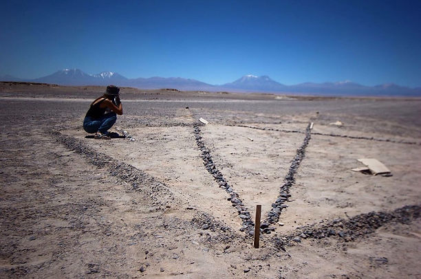
Desarrollo de la construcción del geoglifo en el territorio.

Detalle de la construcción de un geoglifo.


Within the framework of the XXV Latin American Meeting of Architecture Students E.L.E.A. ATACAMA 2017, where our center was invited to develop a work in the cultural area of Chiu Chiu and its surroundings, with the following aspects to consider:
-
Work with a group of 40 to 60 students.
-
Carry out the work in 3 consecutive days.
-
Generate a work that is most respectful of the environment, in terms of its invasion and what will happen to the work once the meeting is over (this was a self-imposed requirement).
GEOGLIFO CONFLUENCE
According to the above, it is proposed to develop the work in the site Confluencia or Junta de los Ríos as the locals call it, which is a cultural area of the pre Andes mountain range in the Atacama Desert. It was thousands of years ago a forced step of the caravaneras troops pre-Tiwanaku influence, and Tiwanaku proper -300 a. C. / 900 a. C-, which frequently traveled from the Andes to the Pacific Ocean and vice versa.
Our interest was focused on making a work that is part of the place, and that remains in the place in a harmonious way and that is a "gift" to the place, build something that could have been done 2,000 thousand years ago.
The geoglyphs are a cultural expression of the original cultures especially of the desert, being the current Chile, together with Peru, the countries where this expression was mostly developed. It is based fundamentally on a "drawing" in the natural soil of the desert, which through two forms -tracking and accumulation- are different types of designs, many of which have not been deciphered, yet they are interpreted in mostly as "signals" on the caravan routes, which developed throughout our Atacama Desert.
METHODOLOGY
The work that our center does is always framed in a contextual research phase, which in this case because it is the construction of a geoglyph, it was very necessary that we could all make a "cultural walk", through the Salado River, that the geoglyph is presented as a signal to the walker. These walks were held in the afternoons and during the three days allowed the students to experientially know several places like Las Vegas de Turi, the town Sanctuary of Ayquina, and the basin of the Salado River, while in the mornings the works proper were carried out. .
This experience not only helped foreign students to discover the Atacama Desert themselves, but also day after day to incorporate new elements into the design of the geoglyph.
This work was designed to be carried out in a participatory way, directly with the students, setting up small work groups, supported by a monitor, an alumnus of our School of Architecture, which will only act as a guide for the work, since the students , who came from different Latin American countries as Europeans, did not know this type of cultural expression even did not know the desert, this being their first time when faced with a very different environment than what they knew.
OBJECTIVES
-
Generate a group and participative work of the whole group of students, both in the design and in the work itself.
-
Allow the foreign student to be an active part of a learning activity in the field, performing a unique type of intervention of the Atacama Desert.
-
Contribute culturally to the Community of San Francisco de Chiu Chiu, closest to the site, with a representation of its culture, which highlights the landscape and territorial values of the site.

Propuesta inicial de la intervención.
Reconocimiento del territorio del Rio Salado.
Trabajo grupal del geoglifo.
FICHA TÉCNICA
Guía
Cristian Games Díaz
Colaboradores
Hernán Barrera Bórquez
Marcelo Méndez
Mandante
E.L.E.A. Encuentro Latinoamericano de Estudiantes de Arquitectura. Desierto de Atacama.
2017